


A realignment of the Elwert and Edy roads has been proposed to accommodate growth in Sherwood West, which was recently brought into the Urban Growth Boundary (UGB). This study will evaluate the feasibility, environmental considerations, and cost of alignment alternatives to support comprehensive planning in Sherwood West.
This project is being completed in partnership between the City of Sherwood, who will complete comprehensive planning for the Sherwood West area, and Washington County, who maintains jurisdiction over Edy and Elwert Roads.
The final report of this study will help guide decision-making by County and City leadership. After the Feasibility Study concludes, work will continue as part of the Sherwood West comprehensive planning process to refine the design and identify funding strategies for future construction. Funding for future design and construction of an improvement will need to be identified as part of Sherwood West comprehensive planning.
Sign up for updates on the Elwert Road & Edy Road Realignment Feasibility Study
Project Timeline
- Goal and objective setting and evaluation of current conditions: (Fall 2025-Winter 2026)
- Data Collection (March 2026-July 2026):
- Traffic and safety
- Environmental conditions and regulations
- Hydrology and stormwater drainage
- Development of alignment alternatives: (Spring-Summer 2026)
Development of conceptual designs and cost estimates of alternatives. - Elwert Road and Edy Road Realignment Online Open House (Aug. 21-Sept 6, 2026)
- Final Analysis and Review Open House Feedback (Sept. 2026)
- Development of Final Report and Recommendations for use in further decision-making and project development. (Dec. 2026)
Study Focus
This study is evaluating the feasibility, environmental considerations and cost of the following options, to support future comprehensive planning in Sherwood West:
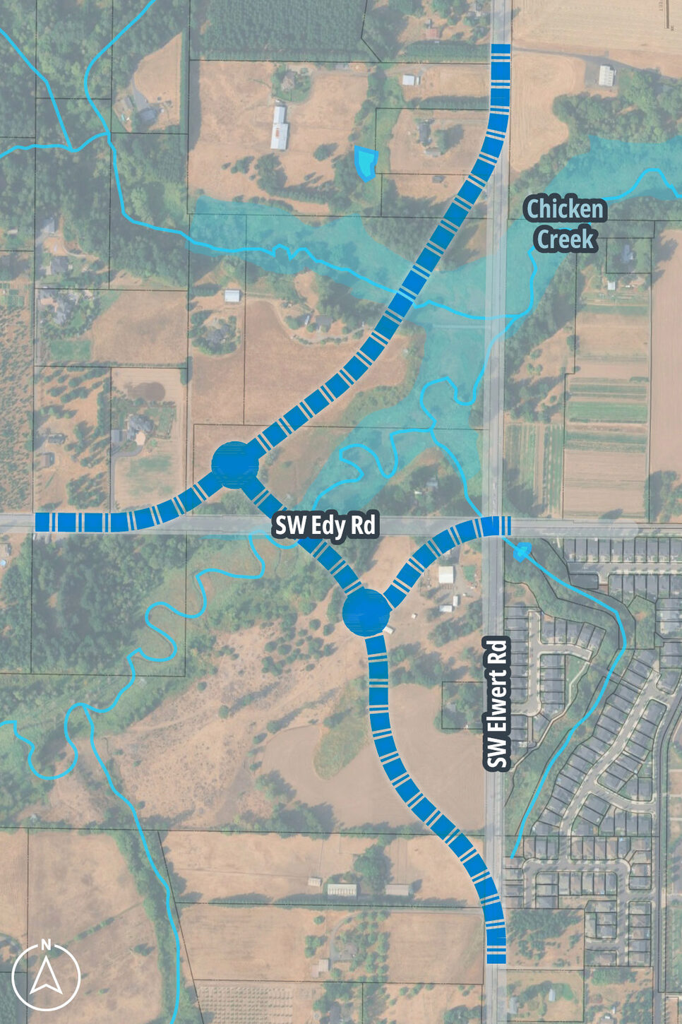
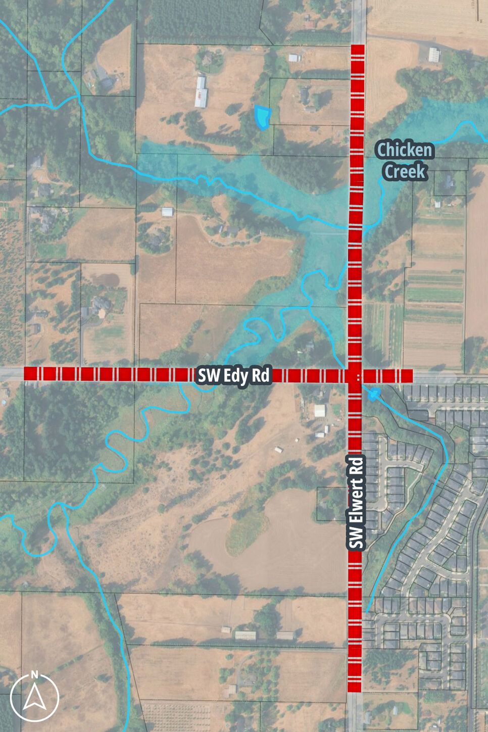
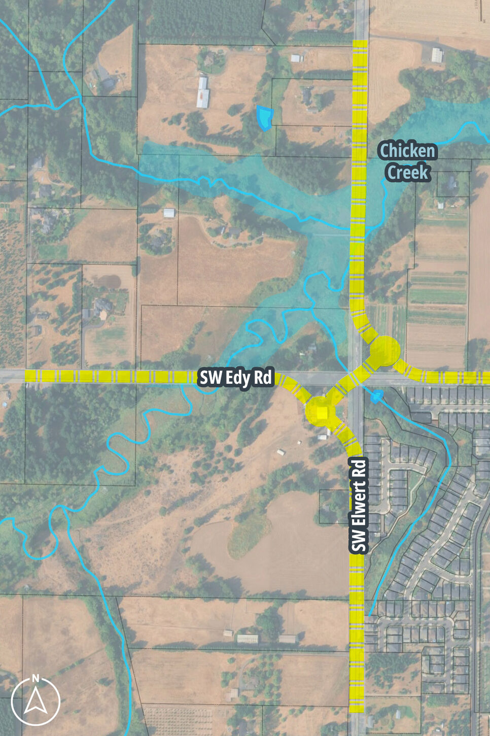
| Alternative 1: Refines Sherwood West Concept Plan alignment, including two roundabouts crossing Chicken Creek at shortest creek width. | Alternative 2: Uses existing right of way with Elwert/Edy as a signalized intersection. | Alternative 3: Uses existing alignments of Elwert Road and Edy Road except near intersection, where two roundabouts manage turning traffic. |
|---|---|---|
| 
| 
|
Public Engagement and Survey Response
This year we welcomed the public to participate in a community-focused planning process to help identify an alternative that best serves both local and regional travel.
In January we met with neighbors in person at the Sherwood open house for face-to-face conversations and to hear first thoughts on what matters most including considerations for project feasibility, safety and livability, mobility and function, and land use and the environments.
With more research completed, we hosted an online open house and survey in September to provide updates and hear input. Here is some of what we learned:
- Where do survey respondents live by ZIP code?
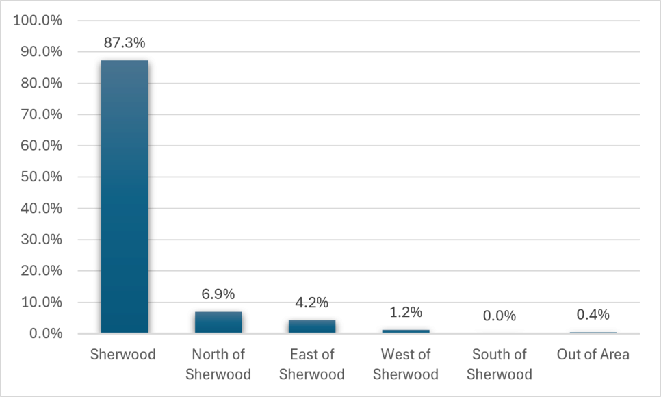
87.3% of respondents live within Sherwood ZIP codes, 6.9% live in communities to the north; 4.2% to the east, and 1.2% to the west of Sherwood. One respondent lives significantly far from Sherwood. No ZIP codes from communities south of Sherwood were reported.
- How do you use SW Elwert Road and SW Edy Road? (Select all that apply)
- 23.5% I live along the road
- 49.2% I live or own property nearby
- 46.2% I commute/drive to destination(s) in Sherwood West
- 46.2% I commute through
- 5% I do not regularly travel these roads
- On average, how many trips do you make through this corridor?
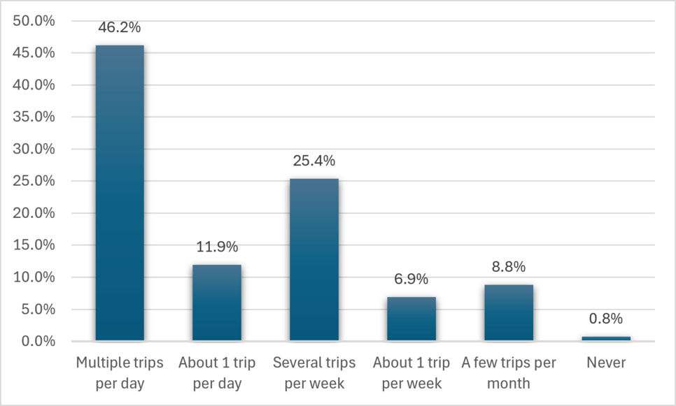
46.2% make multiple trips per day; 11.9% make about 1 trip per day; 25.4% make several trips per week; 6.9% make about one trip per week; 8.8% make a few trips per month and 0.8% never make trips along theses roads.
- Please select which qualities are most important to you for the project outcomes
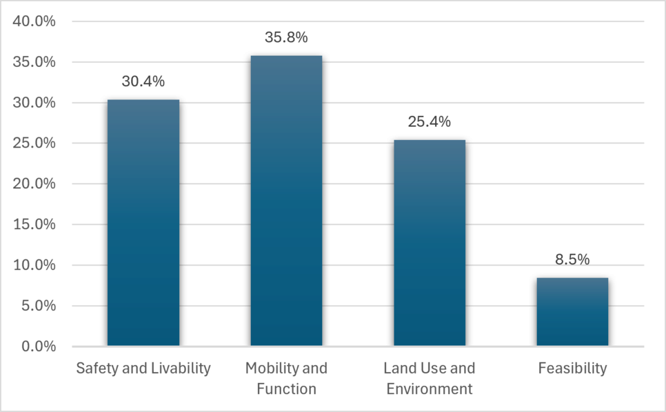
30.4% chose Safety and Livability; 35.8% chose Mobility and Function; 25.4% chose Land Use and Environment, and 8.5% chose Feasibility
- Top Themes: What feedback do you have on the proposed alignment alternatives?
- Preference for practical, low-impact improvements - Many favored Alternative 2 because it maintains the existing roadway alignment, minimizes disruption, and was viewed as the most cost-effective and practical option.
- Protection of property, farmland and environmental resources - Concerns to minimize impacts to private property, farmland, wetlands, wildlife habitat and open spaces.
- Safety and traffic operations - Acknowledgements of existing safety issues including speeding, limited sight distance, traffic growth and school-related traffic.
- Differing views on roundabouts - Some viewed roundabouts a way to improve safety, reduce speeds and support future growth while others expressed that roundabouts could cause congestion, driver confusion and create difficulty for trucks and farm equipment.
- Future growth and corridor function - Some supported larger-scale improvements to accommodate long-term growth while others questioned growth assumptions and preferred solutions addressing current needs with minimal expansion.
- Desire for more information - Many requested information regarding project costs, property impacts, environmental effects, traffic analysis and construction impacts.
- Top Themes: When evaluating the alternatives, are there any factors that we have not yet taken into consideration?
- Property, environmental and community impacts - interest in greater consideration of impacts to private property, farmland, wetlands, wildlife habitat, open spaces and existing residences.
- Cost, construction and project transparency - interest in additional information regarding project costs, funding sources, construction duration, traffic disruption during construction and potential tax implications.
- Future growth and long-term planning - questions about future population growth of the area, industrial land uses, future schools and long-term traffic demands
- Transportation system performance and connectivity - how alternatives will affect the broader transportation network, including regional traffic patterns, cut-through traffic, school traffic, freight movement and agricultural vehicle access.
- Multimodal Safety and Mobility - the importance of considering bicycle, pedestrian, transit and student travel needs in addition to vehicle traffic.
Study Focus
The City of Sherwood’s Sherwood West Concept Plan proposes improvements to Elwert and Edy Road that would require re-construction and widening of the roads. The plan recommends realigning Elwert and Edy roads to manage the impact of road improvements to nearby Chicken Creek and surrounding wetlands, among other considerations.
Contact(s)
| Name | Title | Phone | |
|---|---|---|---|
|
Dyami Valentine
|
Principal Planner
|