

Significant Natural Resources (SNR)
SNR areas are mapped in Community Plans for the urban area and in the Rural/Natural Resource Plan for the rural area. Regulation of development in areas with Significant Natural Resources in both the urban and rural areas is governed by the Community Development Code Section 422.
Significant Natural Resources (SNR) provide benefits to our community and include:
- Land along waterways
- Water areas
- Wetlands
- Fish and wildlife habitats
- Other areas that are significant because of their unique features
Happening Now: Rural Significant Natural Resources (SNR) Updates
We’re updating the natural resource rules and maps for development projects in rural areas by making the standards clearer and easier to understand. These updates are required by recent changes in state law, which call for clear and objective standards for housing in rural residential land use districts.
Timeline - 2026
- Ongoing– Refinement of draft SNR code changes
- Ongoing– Coordinate with agencies and stakeholders
- October– File Ordinance No. 919
- November– Planning Commission Public Hearings
- December – Board of Commissioner Hearings
Rural SNR Property Lookup Tool
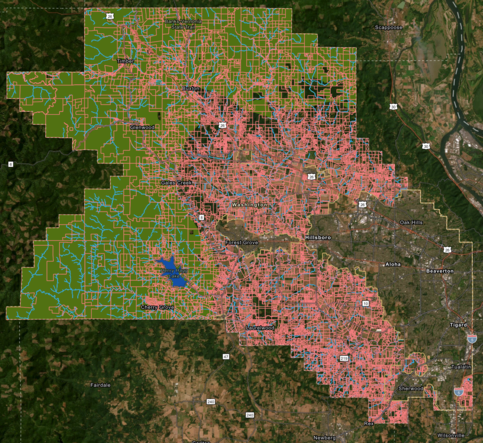
The Washington County Rural SNR Property Lookup Tool shows Riparian Corridor buffer areas and Wildlife Habitat areas where regulations apply for the rural unincorporated area.
Tips for navigating the map:
- Open the look up tool:
- English: Rural SNR Property Lookup Tool
- Spanish: Rural SNR Property Lookup Tool
- Click the search icon near the upper right
- Enter the address or tax lot number in the "Find address or place" that appears when you click the search icon.
- Once you find the property of interest, click/tap on it to see Significant Natural Resource areas.
- Other tools you can explore on the map:
- There is a legend icon directly below the magnifier icon at the top right corner. Click on that to see how the different map elements are displayed.
- The (layer) icon shows the different map elements that you can make visible or invisible by clicking on the eye icon.
- The wrench icon on the left side of the screen gives you options to measure distances and area.
Background about the Rural SNR Update
The County’s current rural natural resource rules were created decades ago, are hard to interpret, and no longer align with today’s state housing requirements. To modernize them, we are using the “Safe Harbor” approach. This is a streamlined method provided in Oregon’s updated Statewide Planning Goal 5 Rules to give local governments a clear, consistent way to update certain natural resource inventories and development standards without needing complex technical studies and analysis.
Standards for Different Habitat Types
For water-related resources—streams and riparian corridors—we are updating their boundaries on the Goal 5 Natural Resources map and developing standards by applying the state’s Goal 5 Safe Harbor method to bring rural standards up to date and make them more predictable for property owners, developers, and the community.
For Wildlife Habitat areas, the state doesn’t offer a clear Safe Harbor path for development standards, so we’ll keep our existing Wildlife Habitat maps but add new clear and objective standards that apply to rural residential development. Property owners will keep the option to use the existing discretionary review path if their situation needs more flexibility.
These updates will improve consistency, meet state law requirements, and help protect rural natural resources in a way that maintains required protections for farmland and forest lands.
Urban SNR Regulations
Updates to SNR regulations happen through the Ordinance Process. Recent SNR ordinances for the Urban Unincorporated Area include:
- A-Engrossed Ordinance No. 901 made changes to the Comprehensive Framework Plan for the Urban Area (CFP) and community plans for the urban unincorporated area to reflect updates to the County’s planning Goal 5 Significant Natural Resources (SNR) program. (December 2024)
- A-Engrossed Ordinance No. 902 made changes to the Community Development Code related to SNRs in the urban unincorporated area to ensure they are clear and objective and meet statewide planning Goal 5 and Metro Title 13 requirements. (December 2024)
- Resolution and Order 24-80, which adopted the Washington County Tree List that was included in A-Engrossed Ordinance No. 902 and is now referenced in the CDC, were also adopted with this ordinance. (December 2024)
- Ordinance No. 914 making minor changes to Significant Natural Resource Regulations and Maps in the Urban Unincorporated Area. (August 2026)
Urban Unincorporated SNR Property Lookup Tool

The Washington County SNR Property Lookup Tool shows Riparian Wildlife and Upland Wildlife Habitat areas where regulations apply for the urban unincorporated area.
Tips for navigating the map:
- Click on the map or link above.
- Enter the address or tax lot number in the "Find address or place" bar at the top left corner of the map screen.
- Don't know the address or tax lot number? Search visually by dragging the map and zooming in.
- There is a legend at the top left corner. Click on that to see how the different map elements are displayed.
- Once you find the property of interest, click/tap on it to see Significant Natural Resource areas.
If you are proposing development or tree removal, please confirm the location of the SNR areas by using the map or checking with Current Planning by email or phone at 503-846-8761.
Resources:
FAQs
Related

SNR: A Focused Look

Contact Development Review/Current Planning
Contact(s)
| Name | Title | Phone | |
|---|---|---|---|
|
Michelle Miller
|
Project Manager, Senior Planner
|
||
|
Suzanne Savin
|
Senior Planner, Land Use
|
||
|
Development Review/Current Planning
|